Fall Creek Flood, 1935
Extremely heavy rains on the night of July 7 and the morning of July 8, 1935, resulted in catastrophic flooding in south-central NYS. The Ithaca office of the US Weather Bureau recorded 7 inches of rain overnight. (Other areas received upwards of 12 or 14 inches.) Shortly before noon on July 8, the USGS gauging station behind the Byway recorded a depth of more than 9-1/2 ft of water over the top of the gauging station dam, with a flow of around 15,500 ft³/sec (= 480 tons/sec, or 29,000 tons/min!).
A detailed 67-page report on the flood appeared in Contributions to the Hydrology of the United States, 1936. You can download a PDF of the report.
The Bull family lived in Forest Home at that time, and a member of the family filmed some scenes of Fall Creek during and after the flood. The History Center in Tompkins County has uploaded this short (4 minute) home movie:
Fall Creek Flood 1935, Bull Family Film
https://www.youtube.com/watch?v=Kn-GB46jujA
The film has three basic parts: The first two minutes depict scenes of a raging Fall Creek and flooded yards. The next minute is not related to the flood or to Forest Home, but instead shows a boy playing with a toy airplane. The final minute shows scenes after the flood waters have receded.
The flood scenes are impressive, although the aftermath scenes might have made more sense to those familiar with what was missing – what had been washed away by the flood. To help us understand what we are seeing, Bruce Brittain has compiled the Viewer’s Guide below, identifying where many of the scenes are shot. The guide is also available as a PDF.
Some scenes are rather short, so it may pay to go through with your finger poised over the PAUSE button.
| Time | Scene description |
|---|---|
| 0:00 – 0:03 | Title Card: “The History Center in Tompkins County” |
| 0:03 – 0:09 | Title Card: “Fall Creek Flood 1935, Ithaca NY, Bull Family Film” |
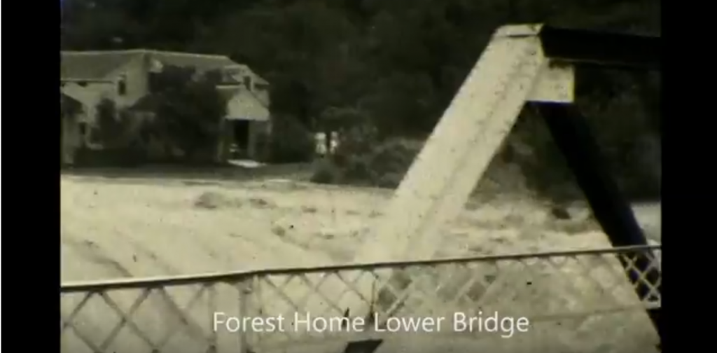
| 0:09 – 0:14 | View upstream from the 200 Block end of the downstream bridge. Downstream bridge in foreground, dam in middle-ground, 145 FHD in background, surrounded by flood waters (or nearly so). Note lattice pedestrian rail on bridge (no longer extant), rather than current vehicular rail. Also note the white paint on the inclined end-post, and what appears to be a concrete deck on the bridge. |
| 0:14 – 0:40 | View from below downstream bridge, on 200 Block side of creek. Looking under bridge at dam and 145 FHD, pans to view downstream. Note unidentified couple on pedestrian walkway, and walkway railing (still extant). |
| 0:40 – 0:49 | View upstream from downstream bridge, dam in foreground. |
| 0:49 – 1:00 | View across creek from side yard of 145 FHD. Pans to view downstream, with 145 FHD in foreground, 200 FHD in background. Note that line of trees that appear to be in the center of creek are actually along the near bank; flood waters have covered the entire front lawn. Note also corn (planted in “hills”) in garden in foreground. |
| 1:00 – 1:04 | View up FHD from Caldwell/FHD intersection. Pans across 300 FHD. Note that the 300 Block of FHD is covered with flood water, and 300 FHD is completely surrounded. Note also narrow clapboard ell, and porch on gable end of 300 FHD (neither currently extant). |
| 1:04 – 1:14 | View upstream from upstream bridge. Pans across 300 FHD. |
| 1:14 – 1:25 | View from Thurston Ave bridge of Triphammer Falls, at foot of Beebe Lake. Old stone Hydraulics Lab (no longer extant) is largely masked by spray. |
| 1:25 – 1:29 | View downstream from point further down Fall Creek. Note overlook on left side of frame. |
| 1:29 – 1:33 | View upstream from point further down Fall Creek. |
| 1:33 – 1:42 | View upstream from another point further down Fall Creek. |
| 1:42 – 1:53 | View of Ithaca Falls. Unidentified couple in foreground, falls in background. Note torn-up brick pavement in foreground, and discharge from sluice toward right hand side of frame. (This giant discharge pipe is still there, but no longer carries water.) |
| 1:53 – 2:00 | Unidentified man in front of unidentified garage. Probably not Forest Home. |
| 2:00 – 2:01 | Tilted, nonsensical image. Perhaps inadvertently filmed. |
| 2:01 – 2:02 | Unidentified boy with large airplane in unidentified location. Probably not Forest Home. |
| 2:02 – 2:44 | Unidentified boy with small bi-plane in unidentified urban location (not Forest Home). Note period vehicles in background. |
| 2:44 – 2:57 | Unidentified boy with small bi-plane in unidentified rural location (not Forest Home). |
| 2:57 – 3:06 | View from side yard of 145 FHD. Note trees that were in middle of flood are now at the edge of the lawn, along the creek bank. |
| 3:06 – 3:12 | View from 100 Block end of downstream bridge. Dam in foreground, 210 FHD in background. Pans to view of driveway for 145 FHD. Note car on driveway, and that dam does not have the notch cut out of it, as it does today. Note also that lawn between driveway and concrete retaining wall has been washed out, exposing old mill foundations. (Driveway and retaining wall are both still extant, lawn has been repaired.) |
| 3:12 – 3:20 | View from 200 Block end of downstream bridge. Dam in foreground, 145 FHD in background. Pans downstream to bridge abutment, providing another glimpse of mill foundations exposed behind the concrete retaining wall. Note uniform flow over entire width of dam, and extra water flowing out from behind the retaining wall |
| 3:20 – 3:24 | View downstream from downstream bridge. |
| 3:24 – 3:29 | View upstream from upstream bridge. |
| 3:29 – 3:31 | View of 300 FHD no longer surrounded by flood waters. Note porch on gable end of building, as well as side porch and narrow ell. Note also quick glimpse up the 300 Block of FHD. |
| 3:31 – 3:43 | View from Thurston Ave bridge of Triphammer Falls, at foot of Beebe Lake. Note old stone Hydraulics Lab (no longer extant) at right hand side of frame. |
| 3:43 – 3:51 | View of Ithaca Falls. Note inverted-truss Stewart Avenue bridge at top of frame. |
| 3:51 – 3:55 | Another view of Ithaca Falls. |
Revised June 13, 2025