Historic Maps of Forest Home
This page shows several maps of Forest Home and its predecessor Free Hollow. The maps are in chronological order. Most maps are available in higher resolution if you click on them.
- Future locations for Ithaca and Forest Home in 1790 Map of Ulysses Township
- Maps of Forest Home and Tompkins County from 1829 Burr Atlas of New York State
- Extract showing Free Hollow from Map of Tompkins County, New York. 1853
- Map of Free Hollow (now Forest Home) from the 1866 Atlas of Tompkins County
- Extract of 1889 Map of Ithaca showing Fall Creek and East Avenue
- Extracts from Clock System Rural Index of 1920
- Hand-colored, printed Cornell University campus map from 1928
- Map of Agricultural Part of Cornell Campus in 1934
- 1938 Master Plan for Cornell Arboretum
- Extracts from 1949 USGS Topographical Map
- Extract from 1951 map of Lands Administered by the N.Y. State College of Agriculture
- 1968 Campus Plan, Cornell University
For more recent maps, see https://www.fhia.org/map/.
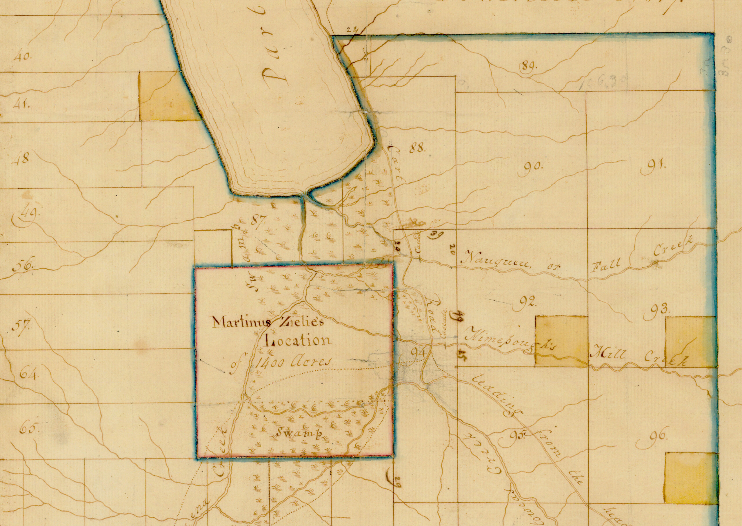
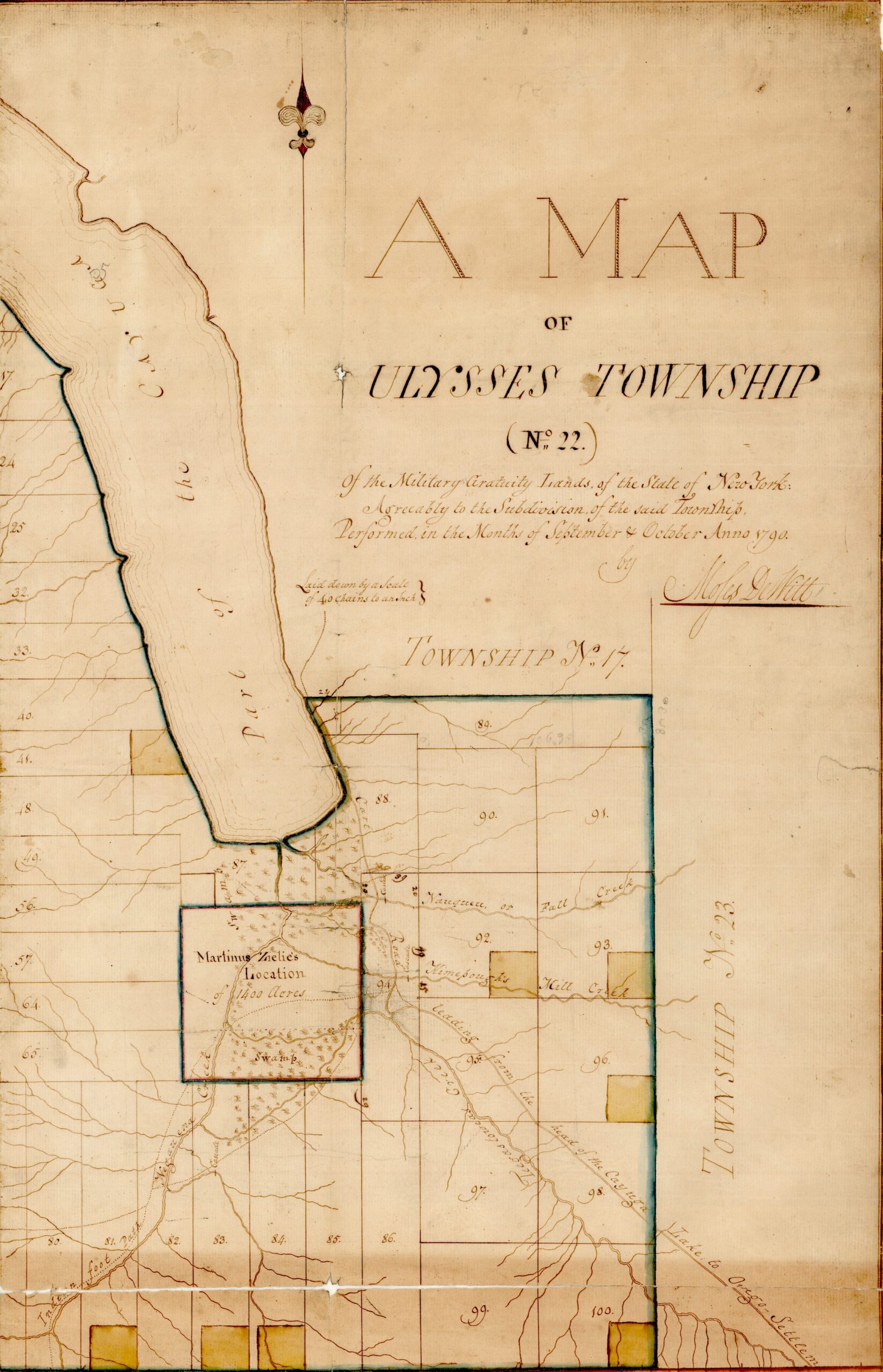
Future locations for Ithaca and Forest Home in 1790 Map of Ulysses Township
The area around Ithaca used to be called Ulysses Township. In 1821 Military Township No. 22 “Ulysses” was subdivided into the current Town of Ulysses, the Town of Ithaca, and the Town of Enfield. This survey map shows the lots into which the Military Tract was divided. By 1821, the Village of Ithaca had been incorporated; it did not become the City of Ithaca until 1888. The square labeled “Martinus Zielie’s Location” is where the City of Ithaca developed.
Forest Home is located in Lots 92 and 93 on Fall Creek. Click on the first map below to see a larger map with the label “Nauqueu or Fall Creek” along the northern of the two creeks that cross Lots 92 and 93. In 1790, there was nothing to note on Fall Creek on the map but a cascade at what is now called Ithaca Falls. Cascadilla Creek was called “Himepaugh’s Mill Creek.” The map identifies a “cart road” from the head of Cayuga Lake to Owego Settlement.
- For the source image for this map at the New York State Archives, see https://digitalcollections.archives.nysed.gov/index.php/Detail/objects/36649.
- For more information about how Ziele’s Location became Ithaca, see https://toursixmilecreek.org/index.php/zielies-location/.
- For information about many local place names, see https://www.tompkinscountyny.gov/historian/place-names.
- For more details about the history of Tompkins County and its towns, see Explaining Tompkins: Its Growth and Government by Carol Kammen and Joe Mareane, a booklet available for purchase at the History Center. See https://thehistorycenter.net/Sys/Store/Products/250284.
Maps of Forest Home and Tompkins County from 1829 Burr Atlas of New York State
The detail from this map of Tompkins County shows three mills on Fall Creek in the town of Ithaca, including a flour mill and a sawmill at upper right of Lot 92, in what is now Forest Home. See legend at bottom left of full map. There is no sign of Beebe Lake. In 1838, Ezra Cornell built the first dam to provide water power for mills below Forest Home belonging to Jeremiah Beebe, transforming a swamp into more of a pond.
Two roadways, presumably cart-paths, are shown going through Forest Home. The line of today’s Triphammer Road, Pleasant Grove Road and Judd Falls Road (north to south, just left of the two mills) was already in use and so was the line of Warren Road to Caldwell Road. The road that became Forest Home Drive is not shown; it was not adopted as an official Town highway until 1831.
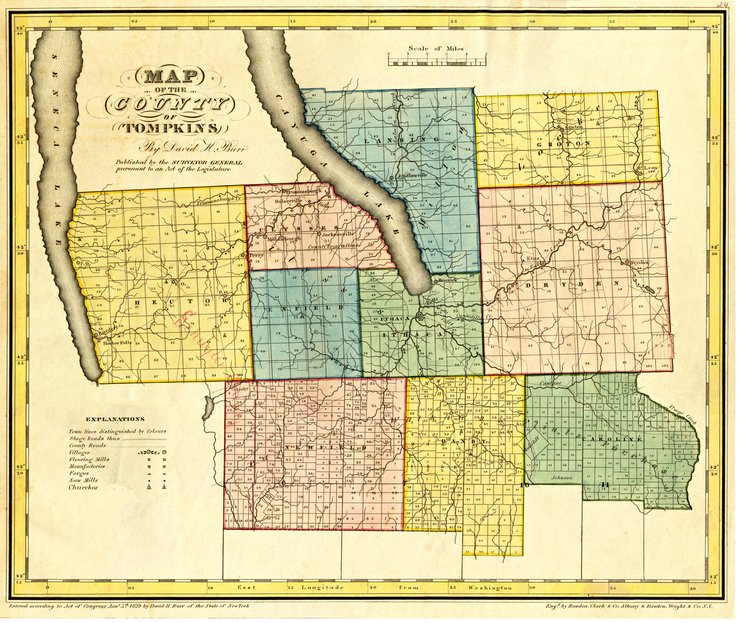
- For entire digitized map at full resolution, see https://tompkins.nygenweb.net/hecht_index.htm
Extract showing Free Hollow in Map of Tompkins County, New York. 1853
Beebe Lake in its current shape did not exist yet. The lake was created when a second dam was built in 1898. It was named after Ezra Cornell’s former employer, Jeremiah Beebe.
In this 1853 map, the road that will become Forest Home Drive follows the current alignment of the Byway, close to the creek, without the cutoff that exists today to get more directly to the bridge. The current roadway alignment for Forest Home Drive is shown on the 1866 map that follows.
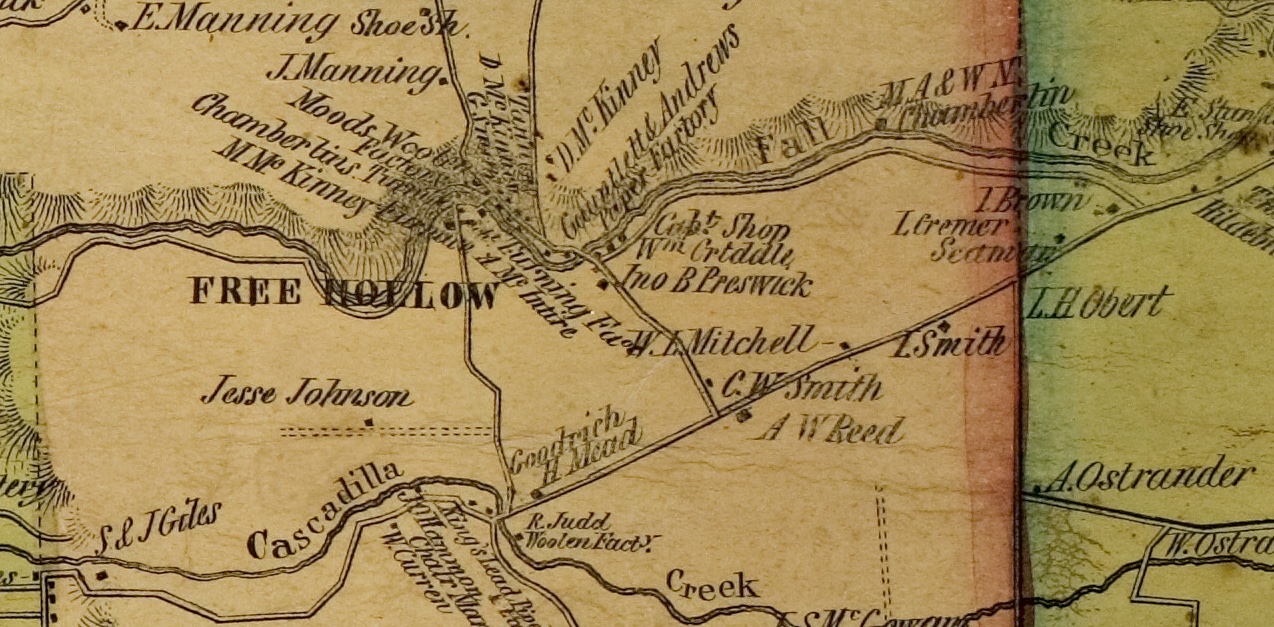
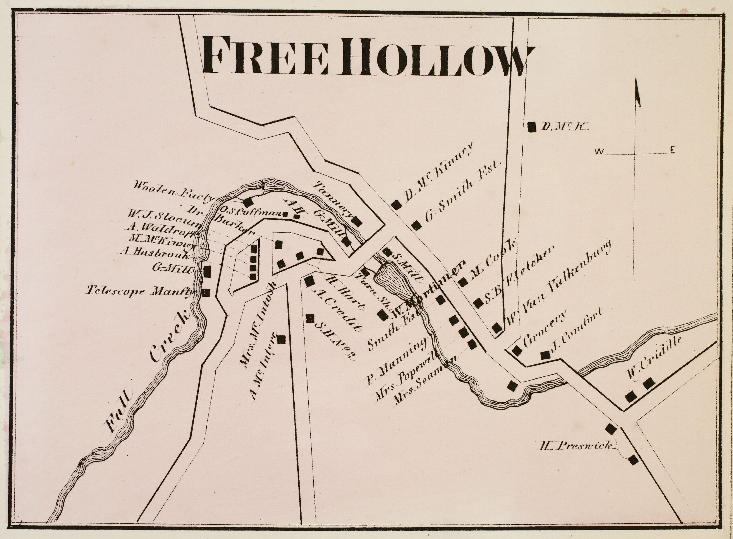
Map of Free Hollow (now Forest Home) from the 1866 Atlas of Tompkins County
Many of the buildings in this map are residential buildings that still exist and are in the Forest Home Historic District.
- See images from the complete 1866 atlas at https://www.cayuga.nygenweb.net/maps/1866tompkins/index.html
- See business directory associated with this map at https://www.cayuga.nygenweb.net/maps/1866tompkins/16319.jpg
Extract of 1889 Map of Ithaca showing Fall Creek and East Avenue
This map extract shows Fall Creek after Ezra Cornell had built his first dam but before the higher dam was built and formed Beebe Lake. Thurston Avenue Bridge does not yet exist; it was built in 1897 in association with the subdivision of Cornell Heights. The eastern side of East Avenue has residences for Professors. This was essentially the eastern edge of the university before the Agricultural College was developed.
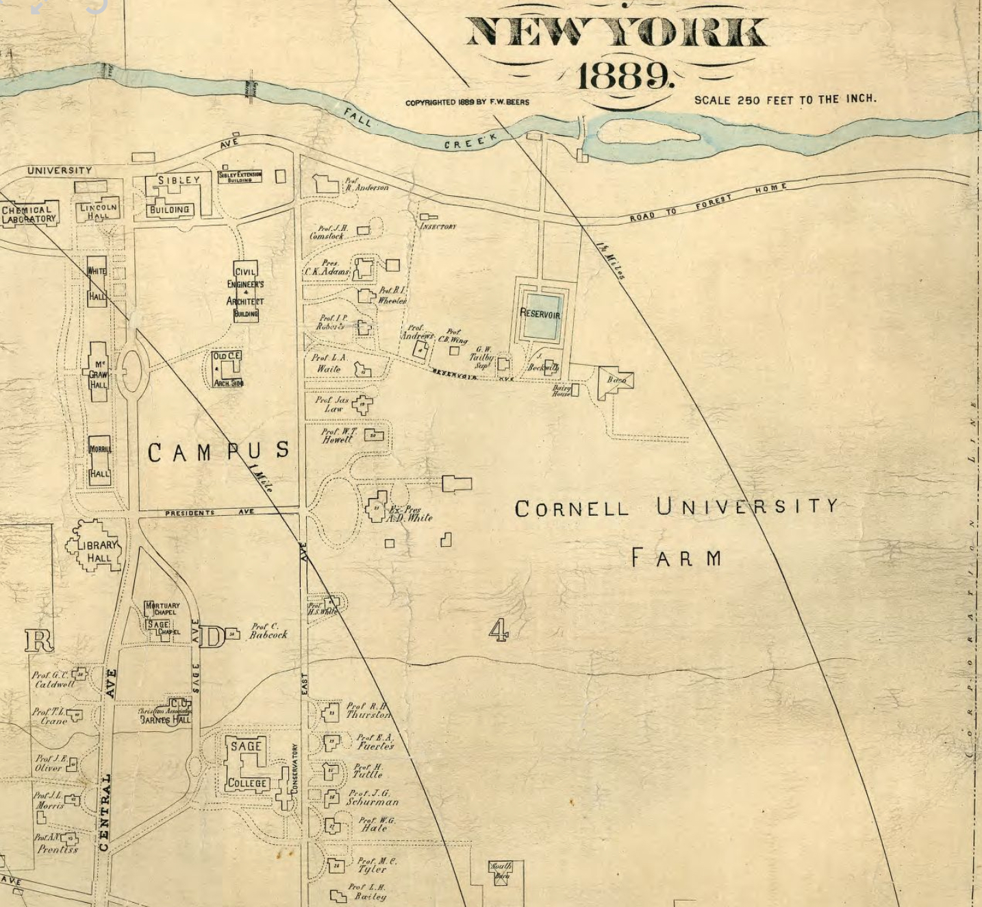
- For full source image see https://nyheritage.contentdm.oclc.org/digital/collection/p15085coll6/id/123/rec/2
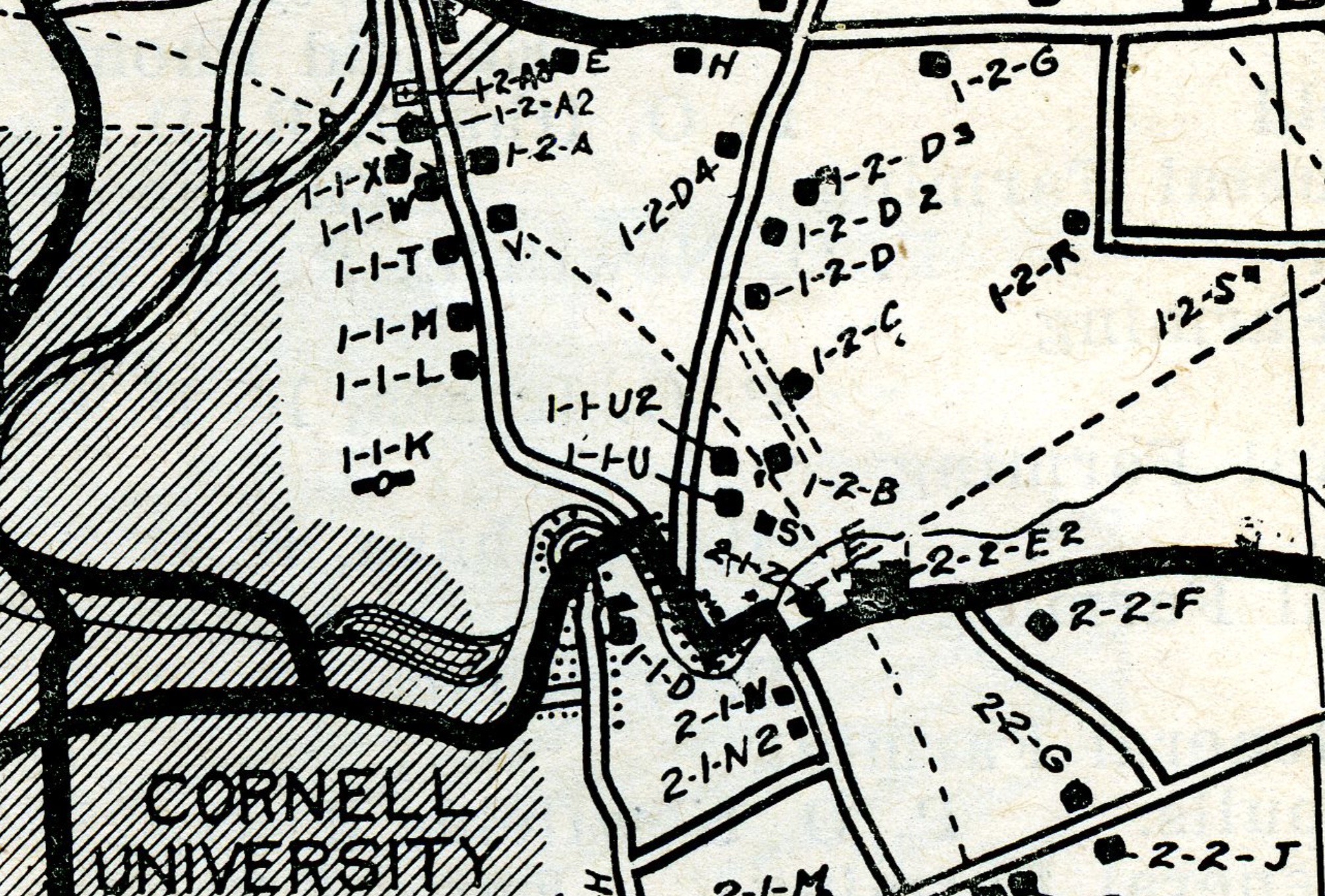
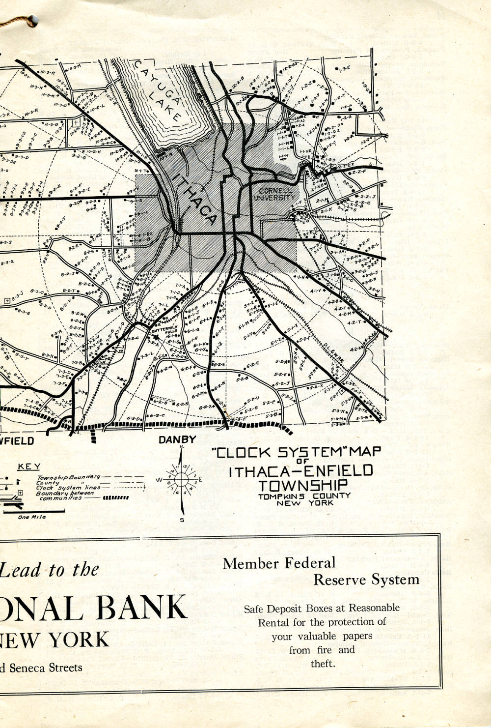
Extracts from Clock System Rural Index, 1920
This map from 1920 used a creative system for giving rural businesses address codes that would let customers find them. John Byron Plato had realized that a Rural Free Delivery (RFD) postal address was only good for delivering mail. The solution he invented was a map-and-directory approach that used direction and distance from a local business center to give farmers a coded address. In 1920, he published a number of Clock System Rural Index directories to cover Tompkins County. The map below is a close-up of Forest Home from a map that covered an area centered on Ithaca. Below that are a page with the entire map centered on Ithaca and a page of listings ordered by the code that Plato created. He could not maintain his business in the face of the depression, but today, this map provides some useful information about the hamlet in 1920.
Note that Forest Home Drive was part of the main route from downtown Ithaca to Cortland. Pleasant Grove Road and Warren Road were less important as roads. Meanwhile, the area near The Byway and Judd Falls Road apparently did not qualify as “rural” by this time.
Examples of properties identified on the map are Pleasant Grove Cemetery (1-2-A3) and Forest Home School #2 (1-1-D). Find Prof. George F. Warren at 1-2-D (now 127 Warren Road); Warren Road was named after his farm. On Caldwell Road are two properties on land by the Water Filter Plant (not shown); Charles Chupp (2-1-N) and Walter Tailby (2-1-N2) worked at Cornell’s College of Agriculture and were active in the Forest Home community for many years, although both moved from this specific location.
- For the entire directory, start at https://nyheritage.contentdm.oclc.org/digital/collection/p15085coll6/id/4533/rec/10 [each page in the booklet is a separate image with an OCR transcript]
- To get directly to the page with the map, see https://nyheritage.contentdm.oclc.org/digital/collection/p15085coll6/id/4547/rec/10
- To get directly to the page with the listings for the Forest Home area, see https://nyheritage.contentdm.oclc.org/digital/collection/p15085coll6/id/4555/rec/10
- For a review of “Clock and Compass: How John Byron Plato Gave Farmers a Real Address” by Mark Monmonier, see http://doi.org/10.14714/CP101.1831
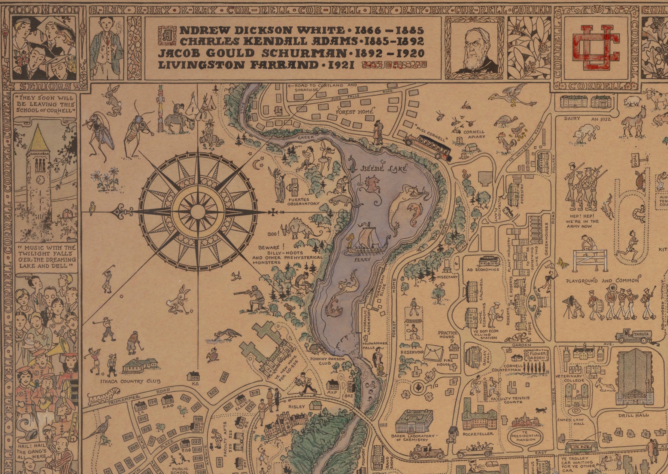
Hand-colored, printed Cornell University campus map from 1928
This map was drawn by Ellen Edmonson (1894-1982). Julia Ellen Edmonson enrolled as a graduate student at Cornell in the fall of 1918, studying entomology and fine arts. She returned to Cornell in the fall of 1925 to study painting and graphic arts with Brauner and lived in the area until she retired about 1960 and returned to Newton, Kansas, where she had grown up. She worked as an illustrator and taught. In particular, she drew and painted technical renderings of wildlife. She is probably best known for her illustrations of fish for the 1927-1940 New York Biological Survey conducted by the Conservation Department (the predecessor to today’s New York State Department of Environmental Conservation).
The underlying map was printed and made available for sale for $1.50 in 1928; it was printed on buff cover paper in two tones of brown. This copy, held by the Cornell Archives, is hand colored. The advertisement that ran in the Cornell Sun on September 25, 1928 described it as, “A Map That Is Different ! Illustrated – and How ! … Decorative — Humorous — Helpful. First Aid for Bewildered Freshmen. Shows where you live, work, and play. And much more. … Send one home to the folks.”
The map extract below is the upper left quarter of the map. It is east-up and shows some of Forest Home, including McIntyre Place and most of Judd Falls Road. Click on the map for a higher resolution version of this extract to read the text and study individual graphic elements.
- For the full map at high resolution, see https://www.jstor.org/stable/community.544531
- For the advertisement that ran in the Cornell Sun on September 25, 1928, see https://cdsun.library.cornell.edu/?a=is&oid=CDS19280925.1.10&type=extractpagepdf
- For a short video showing fish illustrations by Ellen Edmonson in A Biological Survey of the Champlain Watershed (1930), see https://www.youtube.com/watch?v=jHfFE5NKtz0
- For a resource titled Inland Fishes of New York that features many of Edmonson’s illustrations, see http://www2.dnr.cornell.edu/cek7/nyfish/index.html. Look for her signature composed of nested “E” characters.
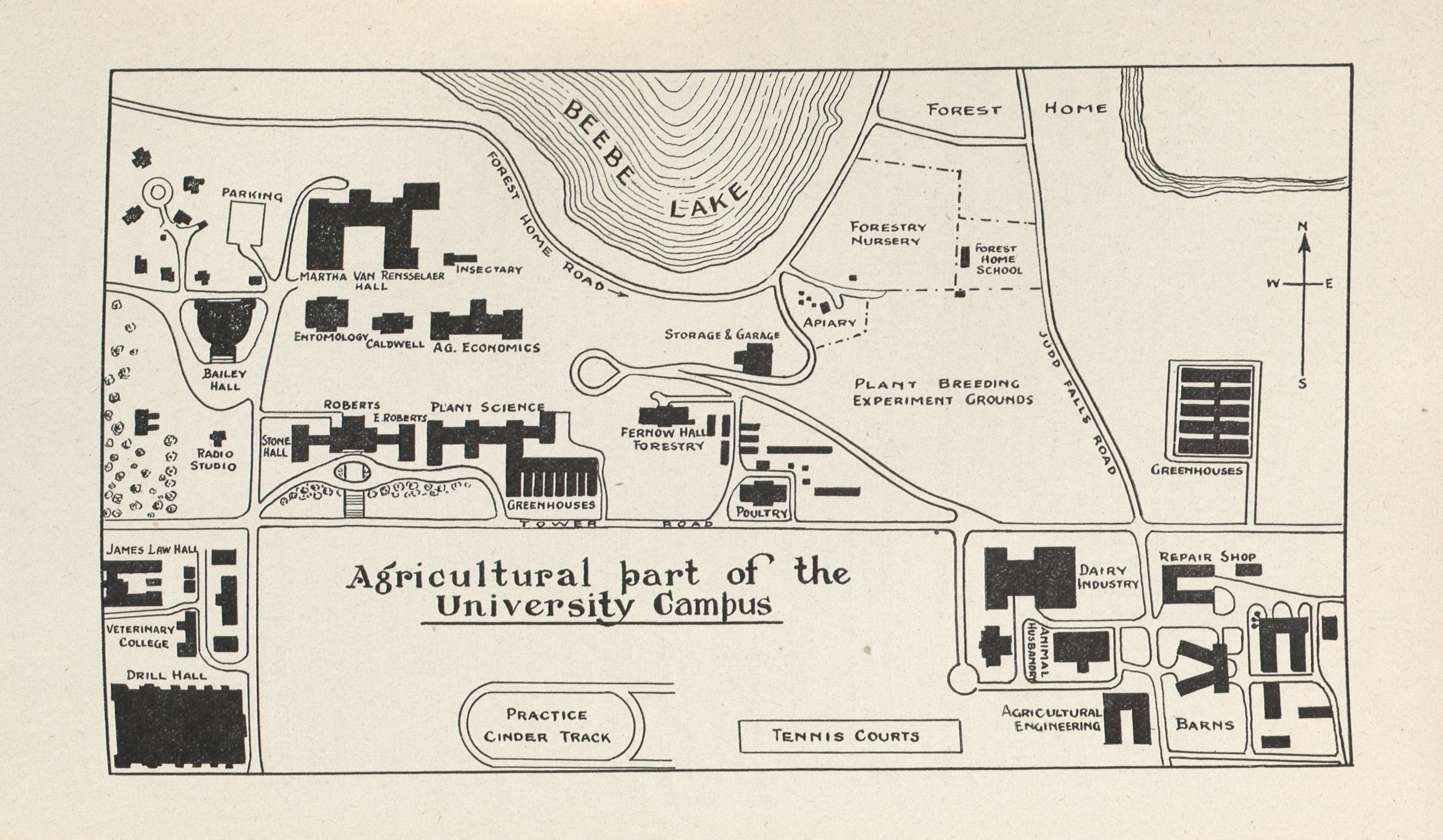
Map of Agricultural Part of Cornell Campus in 1934
This 1934 map of the expanding agricultural part of the Cornell campus is an informal one, published for attendees of a week-long educational event in February 1934, the 27th Annual Farm and Home Week. At upper right is the third Forest Home school, now the Lewis Building of Cornell Botanic Gardens. The area marked Forestry Nursery is where Comstock Knoll and the new Nevin Center are. There is no Plantations or Arboretum Road yet. There is a track from Tower Road near the Dairy Industry building going slightly north of west to the Ag. Quad along the top of the steep bank with a loop to allow pedestrians, and probably light vehicles, to turn back east and downhill past the garage that is now Beebe Hall to the area that was the Plant Breeding Experiment Grounds, and is now the Cornell Botanic Gardens.
Several buildings on Tower Road that were quite new in 1934 are still there and look the same externally. The Poultry Building (built in 1912) is Rice Hall. Fernow Hall (built in 1915) was the Forestry Building. The Plant Science Building was built in 1930. In the Ag. Quad, Caldwell Hall is still there. The building labeled Ag. Economics is Warren Hall (built in 1933). The building labeled Entomology is the first Comstock Hall (built ca. 1912), now the CCC (Computing Communications Center) building. West of the Ag. Quad, Bailey Hall was open as an auditorium for the Ag. School in Fall 1913.
Roberts Hall was the first academic building for the Ag. School (first occupied in June 1907). It was demolished in 1988.
- See source from Cornell archive at https://www.jstor.org/stable/community.545235
- See parent publication at https://hdl.handle.net/1813/42186
- An aerial photo from 1930 is at https://www.jstor.org/stable/community.1199999. It shows an overview of Forest Home and Sackett Bridge under construction.
- For two photos from 1932 of the Plant Breeding Experiment Grounds, also known as Emerson Gardens, see Will the real Maize Genetics Garden please stand up? by Lee. B. Kass and Royse P. Murphy, available at https://mnl.maizegdb.org/mnl/77/79kass.html
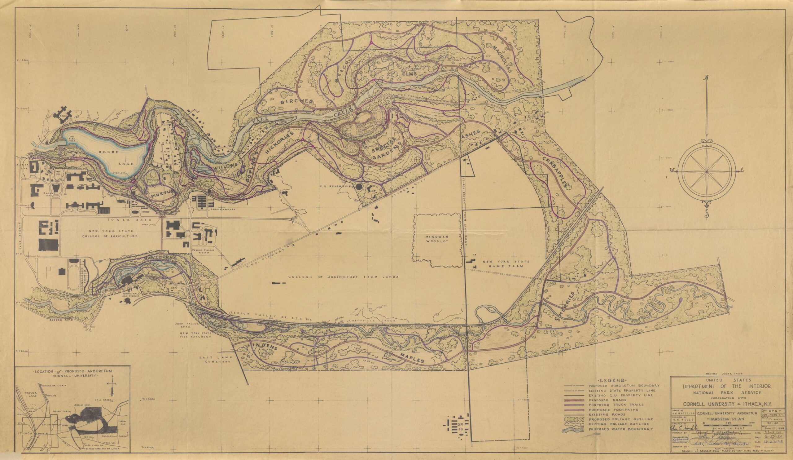
1938 Master Plan for Cornell Arboretum
An arboretum had been planned for over many years, but the opportunity for substantial development came with the formation of the Civilian Conservation Corps (CCC) and the availability of funding to support jobs for young men in the depression. The map below was drawn by Nelson M. Wells, a Cornell graduate who served as Landscape Consultant to the CCC project in the 1930s. It was a very ambitious plan. As Wells wrote in 1938, “The Arboretum lands as now defined are in the form of a giant horseshoe. The eastern or rounded end lies across the tableland at the base of Turkey Hill, south of Varna. The two long arms lie in the parallel east and west valleys of Fall Creek and Cascadilla Creek and enclose the College of Agriculture farmlands. The western limits are the beginning of the gorge formations and here the open arms of the horseshoe embrace the Cornell University campus … To coordinate the varied although harmonious land units, an arterial roadway, or drive for pleasure vehicles, is proposed. Linking together the series of exhibits, it would become a circuit drive through the entire Arboretum tract. Secondary roads, primarily for service, would form spurs, or loops from the main drive. Footpaths would supplement the road system.”
The CCC worked on the arboretum from 1935 until 1941. They established a camp, identified as SP 48, just south of Cascadilla Creek off Game Farm Road (then called Town Line Road as the border between the Town of Ithaca and the Town of Dryden). On this map, the camp is at lower right, just to the left of the legend. The young men cleared and graded land, constructed stone walls, built roads, and planted trees. By 1941, they had built four miles of roads and eight miles of paths, and planted thousands of trees and shrubs. This included building a road to connect the plant breeding grounds near Judd Falls Road to grounds further east. This road between Beebe Lake and Caldwell Road is now known as Arboretum Road, but was called Plantations Road until The Cornell Plantations was renamed The Cornell Botanic Gardens in 2016. To learn in more detail about what the CCC achieved, see The Cornell Plantations: A History. 1947, by Ralph S Hosmer, available at the Hathi Trust [https://hdl.handle.net/2027/mdp.39015068568149].
Much of the detail laid out in the map was not implemented. For example, the road envisaged at the rounded eastern end of the horseshoe was never built; nor was a vehicle bridge built across Fall Creek near Flat Rock. Some infrastructure repairs that were needed were done by the CCC, including rebuilding the bridge on Game Farm Road across Cascadilla Creek, near where the East Ithaca Recreation Way now runs along the bed of the former Lehigh Valley Railroad.
Ideas from the plan, and survey work done during the project, contributed to the continuing development over the rest of the twentieth century. In the early 1970s, the generosity of Cornell trustee Floyd R. Newman enabled new plantings and landscaping and served as stimulus for a fund-raising campaign for further development, including additional roads and paths in the bowl labeled “Special Gardens” in the map. In 1982, the Arboretum was named in Newman’s honor.
- For source image at full resolution, see https://www.jstor.org/stable/community.575368
- For The Cornell Plantations: A History. 1947, by Ralph S. Hosmer, see https://hdl.handle.net/2027/mdp.39015068568149 at the Hathi Trust.
- Several other similar maps were drawn by Wells during the CCC project. These maps are also part of the Cornell Botanic Gardens maps and drawings collection but have not been digitized. A map from 1940 showed a different bridge for vehicles across Fall Creek that was never built — near 310 Forest Home Drive. The catalog record for the collection is at https://catalog.library.cornell.edu/catalog/2084329.
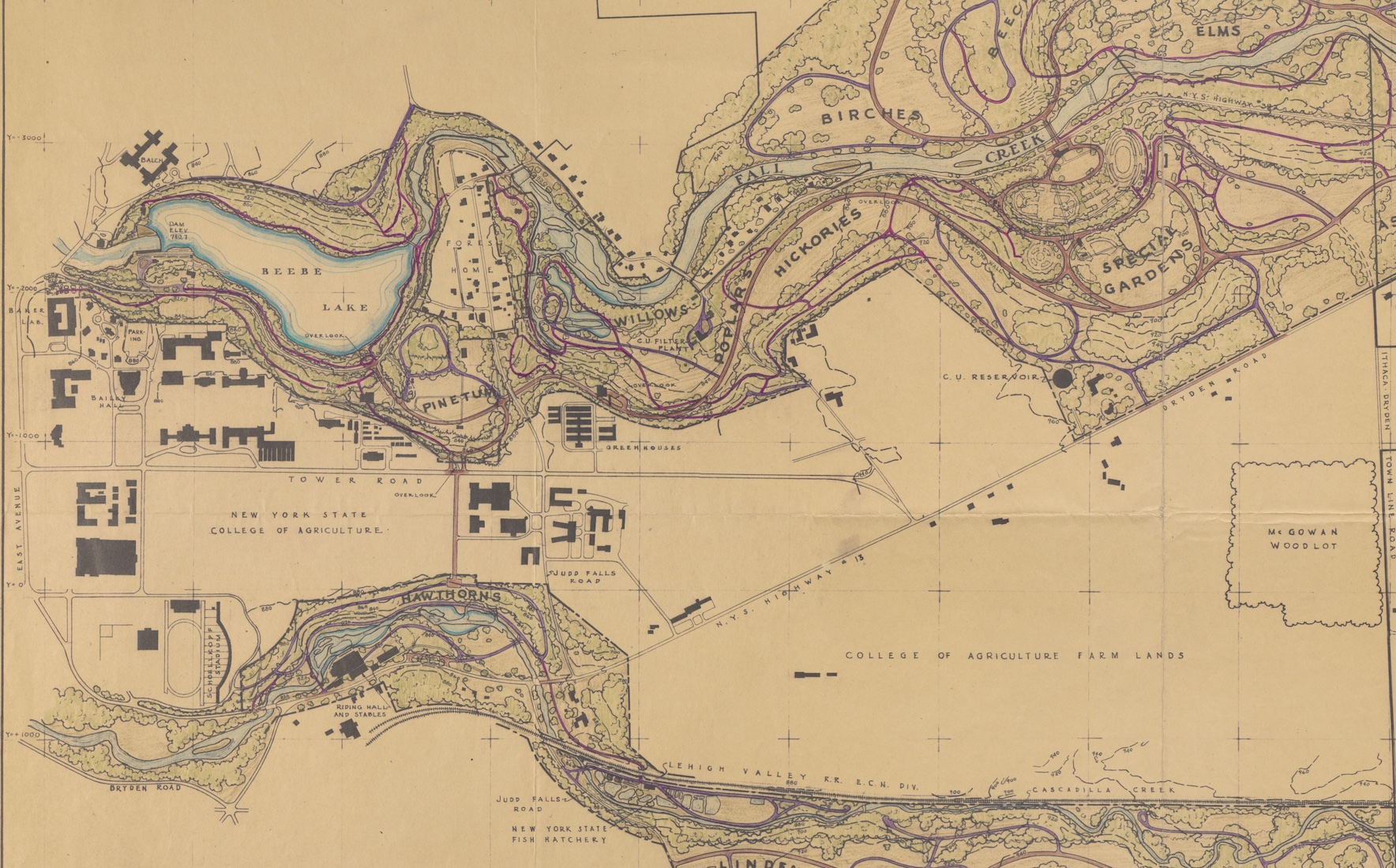
Extract of Arboretum Master Plan focused on area close to campus and Forest Home
The hamlet of Forest Home was affected directly by the development of the Arboretum during the Civilian Conservation Corps (CCC) project (1935-1941) in several specific ways. The extract shown below gives a higher-resolution view of Forest Home in the 1938 Master Plan for the Arboretum.
Firstly, a road was built starting at Forest Home Drive at the southeast corner of Beebe Lake through the Emerson Plant Breeding Grounds, crossing Judd Falls Road, and continuing east to Caldwell Road and into the new arboretum. The Master Plan map shows the new road going under Judd Falls Road, but what was implemented was a pair of ramps up and down, presumably a more feasible solution for the immediate term. A list of suggestions from a special committee on memorial gifts after WW II included a Judd Falls Road underpass, at $25,000. In 1970, Cornell installed a “jug-handle” intersection with a tubular tunnel under Judd Falls Road. In 2024, residents who knew the location in the 1950s and 1960s remember that the ramps had been steep and dangerous. The ramps are visible in the USGS Topo map from 1949, which can be seen below.
Secondly, a wall was created to prevent flooding in an area near the Upstream Bridge. To quote from the Hosmer history of the Plantations: “For many years the area south and west of Fall Creek between the two bridges in Forest Home had always been subjected to inundation at times of high water. This resulted in a deposit of flood trash over the whole area, rendering it virtually useless for any purpose. [Note: 1935 had been a year with particularly bad flooding. See https://www.fhia.org/fall-creek-flood-1935/.] Therefore it was decided to build a stone masonry wall on the south and west bank of the creek of sufficient proportions to confine the flood water of the creek to its natural channel. … This masonry wall begins at the west end of the south abutment of the upper bridge and extends southwesterly, westerly and northwesterly for a distance of 80 feet; it is about five feet thick at the bottom, 3 feet at the top and about 7 to 8 feet in height from the bottom of the footing, which is anchored to bedrock. … at the time of its construction, the natural channel of the stream was cleared of gravel down to bedrock.” This wall has allowed the development of the Mundy Wildflower Garden.
Thirdly, a pedestrian suspension bridge was built over Fall Creek near Flat Rock, replacing a bridge that had been damaged in the 1935 flood. That bridge was rebuilt in 1983 as a class project in Civil Engineering and in 2023, the 1983 bridge was rehabilitated [see https://www.fhia.org/rebuilding-the-flat-rock-bridge/], also as a class project, with active support from the Forest Home community, both financially and as volunteer labor. This bridge connects the Arboretum to many miles of trails on the north side of Fall Creek, including a trail that goes west and then splits into two paths that recombine up on the Cornell golf course, forming a loop. A spur from the western path goes to the corner on Crest Lane.
In addition, we get to enjoy the space the CCC prepared at our doorstep for active recreation and quiet observation of plants and wildlife.
[Note: This map does not show Warren Road, considering it outside the scope of the Arboretum. The path of the Forest Home Walkway is identified, not as a path but because it marked a boundary of Cornell land at the time. Cornell owned 200 Forest Home Drive from 1910 to 1946. The map shows Sackett Bridge, which was built in 1930.]
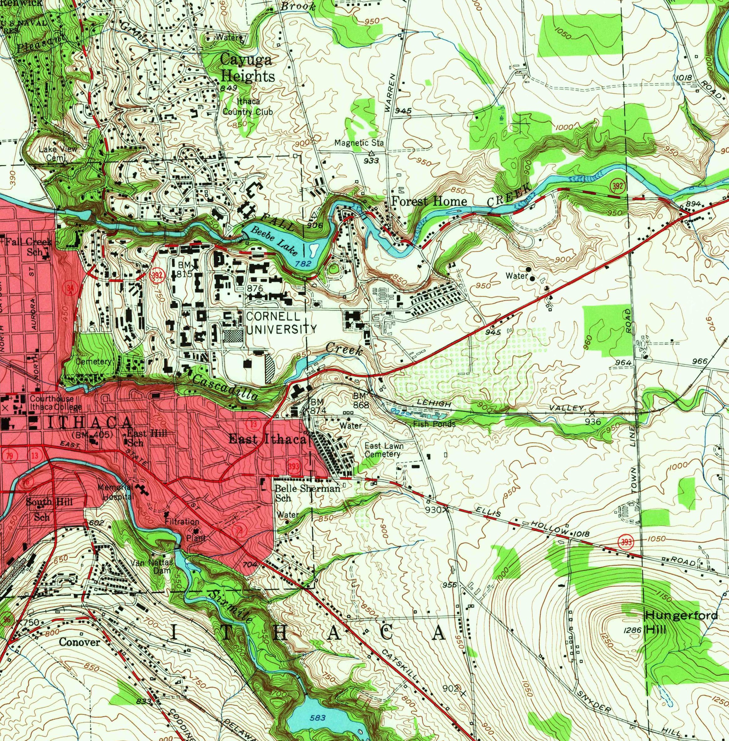
Extracts from 1949 USGS Topographical Map
Most of the buildings in Forest Home today are shown in this USGS Topo map from 1949 but Crest Lane and Fairway Drive did not yet exist. On East Tower Road is a large area of veterans housing, built after WW II for housing the influx of students on the GI Bill. Plantations Road (now Arboretum Road), built by the Civilian Conservation Corps (CCC) in 1936-37, runs from the southeast corner of Beebe Lake through to Caldwell Road and the Arboretum, with ramps where it crosses Judd Falls Road.
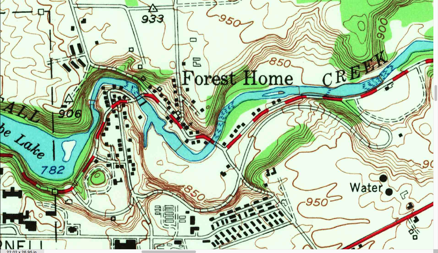
- An extract from a more recent USGS Topo map that covers Forest Home is available on https://www.fhia.org/map/, a page that has more current maps and aerial photographs.
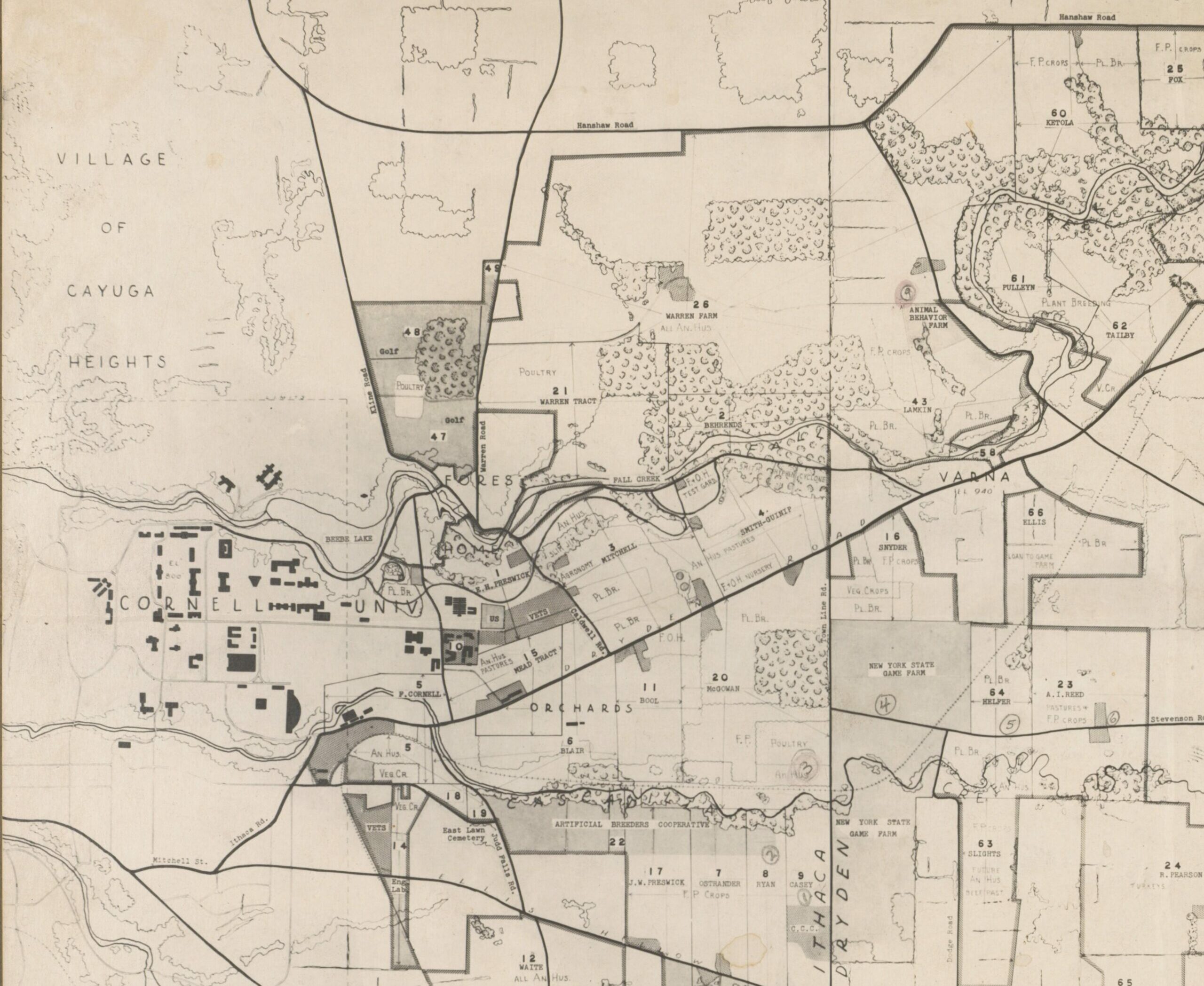
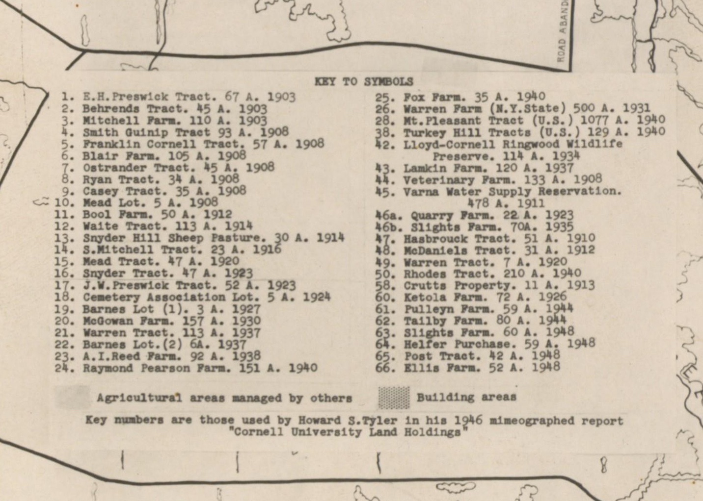
Extract from 1951 map of Lands Administered by the N.Y. State College of Agriculture
The map of Lands Administered by the N.Y. State College of Agriculture was prepared by J.F. Cornman with R.H. Wheeler in 1951. The full map identifies 66 areas of land that were acquired, by purchase or donation, between 1903 and 1951. The extract here focuses on the tracts close to Forest Home and the Cornell campus.
[Note: The map is not accurate in relation to buildings on campus. For example, it shows Risley and Balch halls on north campus, but not Clara Dickson, which was built in 1946. The areas labeled “VETS” are veterans housing, which can be seen in detail on the 1949 USGS Topo map above. The road known today as Pleasant Grove Road is labeled as Kline Road; the name changed in 1953.]
Using the numbers and dates on the map legend shown below the map, the land tracts around Forest Home that were acquired by Cornell College of Agriculture are:
- 1. — 1903 — E. H. Preswick Tract. [67 A]
Near the water filtration plant. See H. Preswick on the 1866 map of Free Hollow above. - 2. — 1903 — Behrends Tract [45 A]
North of Fall Creek near the pedestrian suspension bridge. - 3. — 1903 — Mitchell Farm [110 A]
Farmland east of Caldwell Road, reaching from Forest Home Drive to the Dryden Road (now NY 366). Became part of the Arboretum. - 4. — 1908 — Smith-Guinip Tract [93 A]
Farmland east of Mitchell Farm, reaching from Fall Creek to the Dryden Road. The Smith house in the middle of the tract is visible in the 1949 USGS Topo map above. This house was demolished around 1997. See “Group Asks CU to Spare Home,” Ithaca Journal, November 4, 1996, p2. - 47. — 1910 — Hasbrouck Tract [51 A]
Farm and woodland of area willed to Cornell by Charles A. Hasbrouck. For more about Hasbrouck and the other property he gave to Cornell, part of which is now the Forest Home Park, see the Timeline for Forest Home Park and Hasbrouck Bench, presented by Bruce Brittain at the dedication of the park on September 19, 2015. - 49. — 1920 — Warren Tract [7 A]
A sliver of land separated from the rest of the Warren land by Warren Road. - 26. — 1931 — Warren Farm (N. Y. State) [500 A]
This area of farmland was transferred to the Ag. School by Professor George F. Warren, who had joined the faculty in 1906. In 1907, he bought almost 50 acres, including the “white farmhouse” (now 127 Warren Road), in which he lived until his death in 1938. He acquired additional acreage for the farm later. This transfer included a cluster of agricultural buildings and one building that was used as a residence, a cluster that is still in use by Cornell as the Equine Research Park. - 21. — 1937 — Warren Tract [113 A]
This tract is now mainly part of the Cornell Golf Course. Warren retained the farmhouse and the surrounding land on which Crest Lane and Fairway Drive were later developed.
Warren made an important contribution to the community. In 1911, he purchased the strip of land on which the Forest Home Walkway runs and maintained it to make his commute to campus faster and safer. See The Path, written by his daughter, Martha Warren Hertel in 1979, with a 1985 addendum. George’s children maintained the path after his death, with help from neighbors, and donated the land the path was on to the Town of Ithaca in 1983.
- For the entire map at full resolution see https://www.jstor.org/stable/community.575381
- For a copy of Cornell University Land Holdings – 1946, by Howard S. Tyler. mentioned in the legend of the map see digitized copy from the Division of Rare and Manuscript Collections, Cornell University Library
1968 Campus Plan, Cornell University
This plan of the campus, presented north up for comparison with other maps on this page, omits details for private property in Forest Home, but provides an excellent view of how the hamlet is surrounded by Cornell property. Roads through Forest Home have not changed since 1968 apart from the 1970 introduction of the “jug-handle” to connect Judd Falls Road to Arboretum (formerly Plantations) Road.
The map shows both Hasbrouck Village (built starting 1960) and two areas of housing laid out in barrack style. Near the observatory is an area known as Pleasant Grove Apartments, which opened for married students in 1956 and was demolished in the late 1990s. The other, off Maple Avenue, were barracks buildings originally imported from a military base around 1946 for housing WWII veterans. The complex was renovated for use by married students in 1957 and renamed Cornell Quarters. Cornell Quarters was demolished in 1988. The area of veterans housing on East Tower Road had been demolished in 1952.
The map shows the East Ithaca railroad station and the line towards Etna and Cortland; the tracks for the section to Etna were taken out of service in 1975 and the rail-bed has been re-purposed as the East Ithaca Recreation Way.
The Thurston Avenue Bridge on this map will be the bridge built in 1960 to replace the 1897 bridge. By this time, North Campus is established as an area for halls of residence. Balch Hall (opened in 1929 as a women’s dorm) and Clara Dickson Hall (built in 1946) had been joined by Mary Donlon Hall (built in 1961) and a number of small buildings for special interest communities.
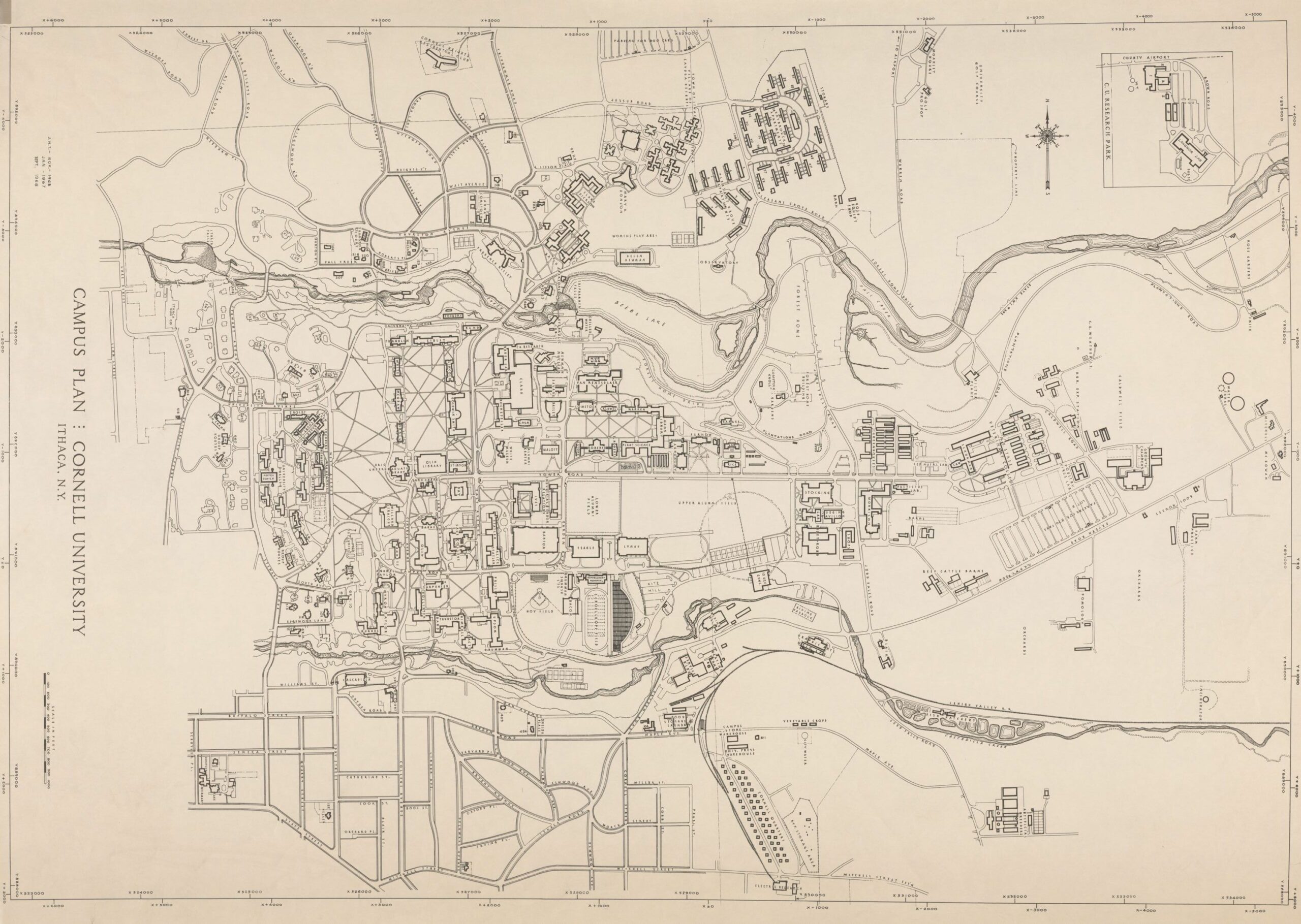
- For the full resolution and other formats available for this image, see https://library.artstor.org/asset/SS35197_35197_19457670
- To read about the railroad, see Ups and Downs of a Rural Line: Elmira, Cortland & Northern RR: 1867 to 1967 and On, available online from Cornell’s eCommons at https://hdl.handle.net/1813/14138
For more recent maps and aerial photographs, see https://www.fhia.org/map/